

Aldermaston Wharf: Lift Bridge and Canal Cottages (SU601671)
Aldermaston Wharf Lift Bridge and former canal cottages. The hydraulic lift bridge takes the A340 road over the Kennet and Avon Canal. It was built in 1981 to replace the previous swing bridge. The bridge pivots on one end allowing clearance for boats to traverse. (photo: Bob Haskins)
")
Aldermaston Wharf: Milestone for Canal (SU605672)
Kennet and Avon Canal milestone by Padworth Lock. The milestone sits beside the lock on the grassy verge behind the mooring posts. These distance markers allowed boat users to gauge where they were in their journeys before maps became widely available, in this case 11 miles from Reading and 7 1/2 miles from Newbury. (photo: Bob Haskins)
, Kennet & Avon Canal 01 220515")
Aldermaston Wharf: Padworth Lock (SU605672)
Padworth Lock on the Kennet and Avon canal at Aldermaston Wharf was built between 1718 and 1723. It was originally a turf-sided lock but was rebuilt between 1982 and 1984 as a brick lock during the period when the canal was totally refurbished. (photo: Bob Haskins)

Bucklebury: Old Foundry (Hedges) (SU553709)
The foundry was started in 1820 on the site of a former blacksmiths. Operated by John Hedges most of the output from the iron works was used in the local farming community. Other items made include churchyard railings, waterwheels and grave markers. The Foundry remained in the Hedges family until 1908, when it was taken over by David William King. In 1946 they were producing castings for agricultural machinery as well as road gratings, manhole covers and meter boxes for Newbury Corporation. The Whatley brothers took over in 1947 and ran the foundry until it closed in 1986. In about 1970 the group of buildings was used for light engineering, garage work and sheet metal work. It is now a private dwelling.
 1")
Greenham Common: Control Tower (SU495645)
Before becoming an airfield this common land was used for troop movements during the English Civil War and also in later centuries. In WWII the British Army used it for training and then it was turned over to the US Air Force. In the 1980’s the site held nuclear missiles. It is now managed by the Greenham Common Trust and is open to the public. The Control Tower is one of the few remaining aircraft buildings. More of its history can be seen here. (photo: Jo Alexander-Jones)
")
Ipsden: Public Well (SU634857)
This winding gear public well, located next to the church in Ipsden, was a gift to the village from Rajah Sir Deonarayun Singh in 1865. Like the matching, if somewhat more ornate well in Stoke Row, this was gifted when Indian rulers heard of the poor public water supply in the area having themselves been recipients of water services by local benefactors in the lower Chilterns region. The 125 ft deep well has winding gear provided by R.J. & H. Wilder of Wallingford and remained in use until the arrival of a local public water supply in 1948. The adjoining churchyard also houses a hand pump and a cast-iron fountain. (photo: Jo Alexander-Jones)
")
Kintbury: Granary (SU385670)
Situated across from the Kintbury Watermill, there is little information on this granary. Historic England’s National Farm Building Types guide describes a granary as a building where ‘grain was stored, which could be detached, sited over another farm building, incorporated in the barn or in the farmhouse’. In this case it looks at be over another building and has a fist storey projecting lift mechanism that would have been used for loading and unloading goods (photo: Jo Alexander-Jones)
 (1)")
Kintbury: GTK Brickworks (SU383668)
The area around Kintbury, like much of Berkshire, had many brick and tile works. In the centre of the village there are four brick faces stamped with G.T.K KINTBURY. The bricks are not in their original locations but have been incorporated in to brick walls to memorialise the local brickmaker George Thomas Killick, who appears in Kelly’s Directory of 1899 as brick maker and whiting manufacturer. Whiting was produced from chalk and used in making paint, talcum powder and other domestic products. The stamped bricks are larger, but thinner than a more normal brick size and have side fixing indicating that they were purely for ‘advertising’ purposes (photo: Jo Alexander-Jones)
 (2)")
Kintbury: Lock (SU385671)
The lock on the Kennet and Avon canal sits close by Station Road, Kintbury, where it crosses both the canal and the railway station. The lock is No 78 on the canal and has a rise/fall of 5 feet 9 inches. There was a private wharf in Kintbury by 1823, although it’s exact location is unknown (photo: Jo Alexander-Jones)
 (3)")
Kintbury: Smithy (SU384669)
Situated on Foundry Close, which is always a give-away, is a rectangular brick building associated with Forge Cottage. Only the original brick structure appears to be unaltered apart from new windows and possible changes in door locations. The building is now part of the cottage dwelling. More details are available on the West Berkshire Heritage Gateway (photo: Jo Alexander-Jones)
 (Aug 21) (1)")
Kintbury: Vicarage Bridge (SU382671)
This bridge was probably built in 1810 by John Rennie. It is referred to as the Kintbury vicarage footbridge, the route to it runs from Church Street over the Kennet and Avon canal and northwards towards Barton Court. It is bridge No 76 and is grade II listed. On one side of the bridge are two railway tracks that have been added to secure the exterior brickwork, as you pass under the bridge using the tow path you can see the deep grooves carved in to the brickwork by the wet cotton tow ropes that would have secured the barges to the horses towing them along (photo: Jo Alexander-Jones)
 (9)")
Kintbury: Water Mill (SU385671)
The mill is now converted in to private housing, but the mill race remains with fine brickwork detailing. In 1733 records show one watermill in Kintbury and previously in 1349 two mills were noted, one a watermill and the other a fulling mill, called Toukyngmill, at Denford. The Kintbury silk mill is mentioned in the Victoria County History Vol 4 and in other references from that era, but whether it occupied this site is unknown. During the time of the Swing Riots in 1830 it is recorded that Kintbury men demanded money from the owner of the mill who paid off the men and thus saved his machinery (photo: Jo Alexander-Jones)
 (1)")
Kintbury: Whiting Works (SU400667)
Irish Hill, situated above Kintbury, has evidence of chalk extraction industry and had a whiting works that closed in the 1930s. Part of the factory structure are hidden in the undergrowth; this is though to be an edge runner mill. Whiting is crushed chalk; it was used in a variety of products including paint, colour wash, talcum powder and to bleach ship sails. Chalk was crushed in water by edge runner stones, before passing through a series of settling pits to get rid of impurities and grade the crushed chalk by particle size. More information on whiting works can be found here and on the West Berkshire Heritage Gateway (photo: West Berkshire Archaeology)
 (1)")
Kintbury: Wooden Turnstile (SU383669)
The turnstile is of interest because it retains its historic metalwork, having been restored in the 1980s and then in 2018. It comprises an upright wooden post with a rotating wooden cross on top, held together with iron brackets around a central pin. The central brackets and pin are original ones. West Berkshire Heritage Gateway suggests that the turnstile is from the 19th century and is probably locally made. The spokes were originally bound with iron bracing, possibly wrought iron, at their ends, but in 2018 this metal was unrecoverable because of damage when the earlier repairs were made. Its purpose is unclear, but it may have prevented unwanted traffic on The Cliffs, which forms a short cut between Station Road and Church Street (photo: Jo Alexander-Jones)
 (5)")
Nettlebed: Old Kiln (SU701868)
The remaining late 17th century or early 18th century bottle-shaped brick kiln in this once thriving brick town. It is a brick conical structure of roughly 10 metres height and 7 metres diameter at the base. There are brick arched doorways to the north and west sides through which the interior can be viewed. Clay for the bricks would have been dug from the nearby Nettlebed Common. The finished bricks, known for their strength, were used in many of the buildings in the Chilterns area. The kiln was converted to burn lime in 1927 and did this until 1938. It then fell into disrepair until restored by local support and Oxfordshire County Council in 1975. It is a Grade II* Listed Building (1181146). More information can be found here. (photo: Jo Alexander-Jones)
")
Newbury: Corn Exchange (SU472670)
The Corn Exchange opened for trade in 1861 to handle the grain growing industry in the environs under the 1581 Charter granted to the town to charge a toll on all corn sold in the market. Corn dealing in the Exchange gradually declined until it ceased in 1983, but not before dealing in oil, insurance and farm machinery had been included. There was also an annual wool market held in the building. As well as its trading role the building fulfilled a social role for the town, holding celebrations, public meetings and dances. 1993 saw it refurbished to become a theatre. More information can be found here. (photo: Jo Alexander-Jones)

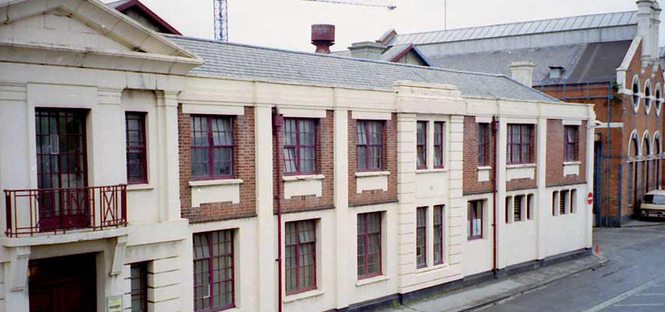
Newbury: Railway Station (SU472667)
Nothing survives of the original Newbury station, opened in 1847, but is thought to have been on the site of the current station. The current station, built between 1908 and 1910, is of the archetypal Great Western Railway design and since opening has not changed much excepting the demolition of a small building by the north entrance and two signal boxes. The station comprises two single-storey brick buildings, one for each platform, and has platform roofs with fine riveted steel columns and latticed girders. (photo: Bob Haskins)
")
Newbury: Town Bridge (SU471671)
The current triple arched stone and brick bridge was completed in 1772. It replaced a number of previous bridges, the earliest being built in the Middle Ages. When in the 1790s the Kennet and Avon was extended to Bath the passage under the bridge, which was already in place, required a line haul for the barges as no towpath was available nor was there room to create one. The impact of these lines can still be seen worn in to the underside of the bridge. (photo: Bob Haskins)
")
Padworth: Ufton Lock (SU617686)
Ufton Lock is the only un-gated lock on the Kennet and Avon Canal as a result of canal restoration work in the 1970s when the up-stream Towney Lock was deepened. (photo: Bob Haskins)
, Kennet & Avon Canal 01 220515")
Reading: Bath Road Pumping House (SU472670)
This low brick building was built around 1870. It is situated on what was the Bath Road reservoir site which was commenced in 1850 as part of the local Reading Water Act of 1851, and is thought to have originally housed two 8-horsepower vertical steam engines with an additional larger one added in 1902 to pump the water supply. In 1927 the two smaller engines were replaced by three electric pumps and an additional diesel pump. The site is now part of a residential development. More information can be found here. (photo: Jo Alexander-Jones)
")
Reading: Bath Road Water Tower (SU472670)
This grade II listed building was built around 1870. It is situated on what was the Bath Road reservoir site which was commenced in 1850 as part of the local Reading Water Act of 1851, and the tower was added as part of the amendment of the Act in 1868. The square tower is made of red brick with blue bricks decoration laid in mainly English bond and was originally divided in to six equal sized rooms. Each room had access from the north and south sides and four of the rooms also had access from the east and west sides. The building was designed to hold a large quantity of water in a tank at height that could supply Reading with water at a suitable pressure. The site is now part of a residential development. More information can be found here and here. (photo: Jo Alexander-Jones)

Reading: Brunel Railway Bridge (SU730737)
The bridge was built by Isambard Kingdom Brunel in 1839-40 as part of the Twyford to Reading section of the Great Western Railway which opened on 30th April 1840 and widened in 1890. It is built on a skew and made of red brick widened in engineering brick with ashlar dressing. It is a listed monument (Historic England) where it is called ‘Reading Railway Bridge and Attached Accommodation Bridge over River Kennet). On the tow path side is a plaque commemorating the 150th anniversary in 1998. More information can be found here. (photo: Jo Alexander-Jones)

Reading: Corn Exchange (SU472670)
The Corn Exchange which dated from 1854 was situated between Market Place, Broad Street and Friar Street; the main building was demolished to make way for a modern shopping development in 1964. All that remains is the entrance facade in Market Place. The architects of the building were J B Clacy and F Hawkes of Reading. Corn exchanges were created as a venue for corn merchants to meet and arrange pricing with farmers for the sale of wheat, barley and other corn crops. With the repeal of the Corn Laws in 1846, which had maintained trade restrictions on imported food and grain and kept grain prices high, a large number of corn exchanges were built across the country. However, with the fall in price of English corn as a result of cheap imports the exchanges lost their value and many started to handle other commodities or became social venues for meetings and as concert halls. Read about The Markets and Corn Exchanges in Reading in Berkshire Old and New No. 30 (2013) (photo: Jo Alexander-Jones)
 (Jo Alexander-Jones)")
Reading: Dowson's Malthouse (SU711740)
Known to many as Drews Ironmongery, this site was originally a malthouse built in the 1870’s and owned by Henry Pendlebury Dowson. In 1872 it supplied malt to H&G Simonds Brewery to supplement their own facilities. When malting stopped it was used by many companies, the most notable being ‘Smallbone’ who were motor engineers and their signage can still be seen as ghost lettering on the building’s side. Drews took over the site in 1977. Local listing is being sought for the buildings and site. More information on the site can be found here. (photo: Jo Alexander-Jones)
 (Drews) 1")
Reading: Fobney Pumping Station (SU706710)
Fobney Pumping Station sits on the Kennet and Avon Canal to the east of Reading close to the sewage works. The brick building still holds much of the original pumping equipment and while no longer used it can occasionally be viewed. Prior to 1891 the station had two water-powered direct-acting turbines with double action ram pumps to each turbine, with the turbines working alternately. This gave an uncertain power supply due to the impact of traffic on the canal and the seasonal water levels. It was replaced by steam-powered pumping machinery – two high pressure, direct-acting, triple expansion, jet-condensing Worthington engines. Each pump could raise 1,500,000 gallons in 24 hours. For a look inside the station as it is now see here. (photo: Jo Alexander-Jones)
")
Reading: Gas Bridge (SU723734)
This bridge is situated on Gas Works Road in Reading and crossing over the Kennet and Avon canal. It linked the main gas producing site in King’s Mead and the Gas Governor House closer to town. It has two integral 24” mains which run under the bridge’s road surface designed to carry the gas. Find out more about the Gas Industry in Berkshire here (photo: Jo Alexander-Jones)

Reading: Gas Company Offices and Showroom (SU715735)
The Reading Gas Company opened its offices and showrooms in 1896 on the corner of Friar Street and Cross Street, Reading. The building had two showrooms – one for domestic appliances and one for lighting. The site remained a gas showroom well in to the 1990 and is now owned by the Haslams estate agency. Find out more about the Gas Industry in Berkshire here. (photo: Jo Alexander-Jones)

Reading: Gas Governor House & Social Club (SU723734)
Situated on Gas Works Road and backing on to the Kennet & Avon Canal this site was built in 1903 and comprises two buildings; one the Social Club for the gas works and the other, larger building, was the Governor House. The Governor House was where the gas pressure and volumes were regulated before entering the gas distribution system from the production site further down Gas Works Road. It has lain derelict for many years. Find out more about the Gas Industry in Berkshire here (photo: Jo Alexander-Jones)
")
Reading: Horseshoe Bridge (SU730738)
When the railway bridge over the Kennet and Avon canal mouth by Isambard Kingdom Brunel was widened in 1890 this ‘horseshoe’ bridge was built. It spans the canal mouth and was to allow for the passage of horse-drawn boats along the River Thames. It opened in 1891. Originally a wooden structure, it was restored in the late 1990s with metal supports. Read more about the bridge in BIAG News No 26 (photo: Jo Alexander-Jones)

Reading: Huntley & Palmers - Chocolate Island (SU722735)
Chocolate Island is in the middle of the Kennet & Avon Canal by Blake’s Wharf. It was where Huntley and Palmers, the biscuit makers, kept their raw ingredients. It is totally surrounded by water so the ingredients, especially the expensive chocolate, could be controlled and kept safe from potential theft. It is now reached by a pedestrian bridge from the south bank but this is often locked and has a statue of an angler which makes it easy to locate. (photo: Jo Alexander-Jones)

Reading: Huntley & Palmers - Social Club (SU723734)
Sole surviving building from Huntley & Palmers’ King’s Road biscuit factory. It was converted into the Factory Social Club in 1938, following the construction of the larger factory located next door on the King’s Road which made its role redundant and left it vacant. It is now private accommodation. (photo: Jo Alexander-Jones)
")
Reading: Huntley, Boorne & Stevens - Biscuit Tin Factory (wall) (SU717729)
Hidden in St Giles Close, Reading, this structure is the sole surviving wall of the Biscuit Tin Factory of Huntley, Boorne & Stevens which existed on the site between London Street and Crown Street. Originally a workshop wall it is now part of a nightclub. The wall is unlisted and has faced a number of planning threats.
Joseph Huntley was an ironmonger, tinsmith and brazier in London Street in the 1830s. His shop was opposite the first shop baking what would later be Huntley & Palmer and was run by his father and brother. He was joined by James Boorne in the 1840s, and by Samuel Stevens in 1872. The firm made biscuit tins for Huntley & Palmers from the age of the stagecoach to the motorway age. At first, the tins were plain, with paper labels, but eventually the firm came to specialise in printing on their tins, and producing decorative and novelty tins. Their extensive works had entrances in London Street, Crown Street and Southampton Street. Profits declined during the First World War, and the firm became a subsidiary of Huntley & Palmer. In 1959 they began producing tins laminated with a plastic coating – lamiplate. They looked around for a factory site to accommodate the long production lines they needed, and eventually settled on a former aircraft hangar on the former Woodley Aerodrome site, moving in during 1968-69. At the time they had 700 employees. In 1960, the parent company had joined with W & R Jacob, and Peek, Frean & Co., to form Associated Biscuit Manufacturers. A.B.M. was swallowed up by Nabisco Brands in 1983. Huntley, Boorne & Stevens was no longer needed by the group, and was sold to the Linpac Group. The production of aerosol cans became an important part of the output for the last 20 or so years of the company’s existence. They disappear from the Reading telephone book between 2003 and 2004. Find out more here. (photo: Jo Alexander-Jones)
 b")
Reading: King's Meadow Baths (SU719739)
This open-air lido was opened as the Ladies Swimming Bath in 1902, and is believed to be the oldest outdoor municipal pool surviving from the Edwardian era. It was originally fed from the River Thames. The Grade II listed building has recently been refurbished keeping many original features after falling in to disrepair and being closed in 1974. You can read more of its history and current use here. (photo: Bob Haskins)

Reading: Reading Bridge (SU718740)
Reading Bridge taking Caversham Road across the River Thames. This single-span ferro-concrete bridge was designed and built by L G Mouchel & Partners Ltd and Holloway Brothers (London) Ltd. It was opened on 3rd October 1923 and at the time was said to have the longest span of its type in the world. The Manchester History Net has a good summary of its design and structure. (photo: Bob Haskins)

Reading: Former 17th Century Silk Mill (SU702729)
Halfway along Brunswick Street in Reading is an old gabled building. It is believed to have originally been a 17th century silk mill built by Huguenot refugees from the German city of Braunschweig – The location giving the street its current name. The building is now private housing (photo: Jo Alexander-Jones).
While there is no evidence for the tradition that mulberry trees were presented to the town by Queen Elizabeth I, 1560, in order to foster a silk industry there was a silk industry in the town. Records of Reading Corporation show a John Fowler (d. 1611), “superintendent of the extensive silk manufacture of the town,” and Robert Smart, silk weaver, 1640. In 1816 John Man mentions a gauze factory with 109 looms, making gauze, crepe, muslin, and plain and figured silk dress material. Thomas Simmonds was manufacturing in Minster Street, Reading in 1830. c. 1830 – Williams and Simpson were making silk ribbons in The Oracle workshops, and also in London. Matthew Green was making “shag” (coarse silk) in East Street, Reading and Reynolds and Macfarlane were manufacturing silk in the Abbey ruins. In the 1830s there were 3 silk factories in Reading. The one on Coley Place remained standing until the early 20th century. In 1841 Messrs. Baylis built an extensive silk factory on King’s Road. Huntley and Palmers moved from London Street to the almost-new buildings of a failed silk factory in 1846.
")
Reading: Simonds Brewery - Malthouse (SU713729)
The Malthouse is one of the few remaining buildings from the huge brewery complex of H&G Simonds in Reading. Said to date from the 1850’s this impressive building is now used as private accommodation. You can read more of the history of the Simonds brewery in this article from the Berkshire Archaeological Journal No 68 (1975). (photo: Jo Alexander-Jones)
")
Rotherfield Greys: Greys Court Horse Wheel (SU725833)
A restored example of animal-powered machinery now installed at the National Trust site of Greys Court (in the shop area). The horse wheel originally drove pumps which raised water from a deep well at Shabden Park, Chipstead. You can read more about the restoration by BIAG here. (photo: Jo Alexander-Jones)
")
Sheffield Bottom: Sheffield Mill (SU645704)
Visible from the Kennet & Avon canal towpath are the remains of Sheffield Mill. The first mention of a mill here was in 1086. By the second half of 13th century there were two mills – a fulling mill and a corn mill, which later were granted to Reading Abbey and passed in to private ownership at the Abbey’s dissolution. By 1811 the site had become a paper mill and the associated mill house (listed) was in place. Paper manufacture was still in operation in 1869 and continued until the mill burned down in 1877. The mill was then bought by the miller at Burghfield Mill to secure the water rights.
More information is available in this publication from the Berkshire Local History Association: Berkshire Old and New No.21 2004 – Paper Mills in Berkshire – A Preliminary Survey and on the West Berkshire Heritage Gateway (HER Record Number MWB6257)
")
Stoke Row: Maharajah's Well (SU679839)
This well was constructed in 1864 to provide water for the village of Stoke Row. However, it is most interesting from an IA perspective as one of the few remaining examples of the work of the Richard Wilder’s Iron Foundry at Wallingford, then a Berkshire town. You can read more about the Well here. (photo: Jo Alexander-Jones)
")
Theale: Garston Lock (SU655707)
This is one of only two remaining turf sided locks on the Kennet and Avon Canal. It’s a scheduled ancient monument. The other can be found at Monkey Marsh Lock in Thatcham. (photo: Bob Haskins)
, Kennet & Avon Canal 02 220515")
Wargrave: Chalk Pit Quarry (SU788782)
The pit was initially excavated in the mid-1800s and was operated through to the 1930s; it produced chalk, which is a soft porous limestone used in a number of industrial processes. This pit had lime kilns that were used to produce lime from the chalk which was then sent in wicker baskets by horse and cart to Temple Mill near Maidenhead for use in paper making. The lime was also used in the building trade and in agriculture ass fertiliser. The Berkshire Geoconservation Group have more information on the geology of the pit. Half of the site is now used as a cemetery for St Mary’s church and contains a grave stone of the farrier Charles Henry Sparks adorned with anvil, hammer and tongs. The site of the quarry can be seen on the 1913 OS map. The quarry is now a wildlife area and is now accessible from a footpath off Braybrooke Road. The quarry is listed by Berkshire Archaeology in the Heritage Gateway (photo: Jo Alexander-Jones)
")
Wargrave: Ferry Landing (SU784787)
At the end of Ferry Lane in the south of the village there is a landing stage of what was once the local ferry crossing point. British History Online cites a ferry across the Thames operating in the 17th century. The Book of Wargrave, by Rosemary Gray & Sue Griffiths note that the ferry was here prior to 1837, then the following year it moved to outside of the George and Dragon Public House, where it can be seen on the 1913 OS map. These days the site is still used for landing pleasure craft. The landing is listed by Berkshire Archaeology in the Heritage Gateway (photo: Jo Alexander-Jones)
 a")
Wargrave: Old Petrol Pump (SU785786)
On the east side of the High Street, by what was the White Hart public house is an old green manual Avery-Hardoll Cleveland model petrol pump. It is missing the top insignia and any branding. More information on how this type of pumped worked can be found here and details of the Avery-Hardoll company here. The pump is listed by Berkshire Archaeology in the Heritage Gateway (photo: Jo Alexander-Jones)
 a")
Wargrave: Railway Boundary Markers (SU780784)
Close to the railway bridge on Loddon Drive are two Great Western Railway boundary markers. These metal markers were used to define the limits of the railway’s land ownership and were mainly used when fencing was not appropriate. These markers are undated and have ‘British Railways Western Region’ and ‘Boundary’ on their tops. The roundels are mounted on a short length of broad-gauge track. Here are a few more markers from the Great Western Railway. The markers are listed by Berkshire Archaeology in the Heritage Gateway (photo: Jo Alexander-Jones)
 a")
Whitchurch: Toll Bridge (SU534772)
The existing bridge, built in 1902, links Whitchurch-on-Thames and Pangbourne across the River Thames and is the third bridge at this location. This site has been a crossing point for centuries originally crossed by ferry. The latest bridge is constructed of iron, but sadly not from a local ironworks. It was designed and built by the Cleveland Bridge and Engineering Company Ltd. It is Grade II listed. Bridges and their tolls maintained the roadways that then allowed industry and manufacturing the thrive. More information can be found here. (photo: Jo Alexander-Jones)
")
Whitchurch: Toll House (SU534772)
The original Toll House dates back to 1792 and was built close to the road to facilitate the collection of the fees, which were taken from the porch doorway. Now tolls are collected from a more recently built brick toll house in the roadway. It is Grade II listed. Bridges and their tolls maintained the roadways that then allowed industry and manufacturing the thrive. More information can be found here. (photo: Jo Alexander-Jones)
Windsor: Windsor & Eton Riverside Station (SU964770)
The terminal station of the London & South Western Railway’s branch from Staines. It was designed by Sir William Tite and opened in 1851. It is a grade II listed building. (photo: Bob Haskins)

Windsor: Windsor Bridge (SU967773)
A cast-iron three span bridge dating from 1823 on rusticated ashlar pointed cutwaters and ashlar abutments designed by Charles Hollis. The bridge is grade II listed. (photo: Bob Haskins)
